
Recent Posts
Categories
- Advanced Solutions (12)
- Archeology (7)
- Event Management Solutions (3)
- Events (18)
- Grocery E-commerce (18)
- Innovation (19)
- IT Services (14)
- Land Stewardship (10)
- Locker Solutions (19)
- Natural Resources (7)
- NOC Operations (12)
- Operations (10)
- Science Projects (10)
- Security (8)
- Smart Retail (20)
- Supply Chain (12)
July 6, 2017
Millions of small, family-operated retailers known as nanostores are the main source of consumer-packaged goods (CPG) for many consumers in Africa, Asia and Latin America. In China, nanostores have managed to compete successfully with larger retailers. Many large Fast Moving Consumer Goods (FMCG) manufacturers and distributors such as Unilever, P&G, Nestlé, struggle with how to efficiently supply thousands of nanostores that are typically found in large cities of developing countries.
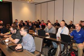
Several of our team members at the Centre de Congrès de Saint-Hyacinthe, Quebec at the Millenium Micro Conferance getting up to speed on the latest technology with partners Solarwinds, Lenovo, HP and Microsoft.
ABM Lower Mainland is about connecting communities and companies with complementing goals, supporting economic diversification and innovation while providing opportunities to form partnerships that result in new ventures, stronger market presence and a sharper competitive edge. We are looking for companies that represent all industry sectors including manufacturing, technology, tourism, aquaculture, agriculture and retail etc.

Elite customer experiences demand an evolving fast-retail strategy defined in short time horizons (6-12 months) with close-to-consumer self-service channels including proximity-based inventory distribution, fulfilment network and on-demand delivery, with both traditional grocery standards (such as milk and bread) together with health-oriented dietary choices (such as salads and organics).
2. There is the increasing complexity with the expansion of e-commerce logistics and the omni-channel model. The solution to this problem is to rethink food production/processing, shipping and location strategies, such as offering ship to store, in-store fulfilment and automated locker networks, using stores as a distribution center and increasing the marketing and visibility of high-volume and convenience-focused products. The enlarged convenience store (c-store) model potentially checks all these boxes.
3. C-Stores, along with smaller-footprint stores (1000-2000 sq. ft.), allow for agile operational models for profitability and supply chain revenue growth as both proof of concept modelling and real-time analytics for lessons learned to help win the online grocery battle.
With a focus on enhancing the level of redundancy in our systems we are taking the fist step in building out our Kelowna cluster. A key part of our enterprise risk management plan is having our systems geographically distributed. Our first node in Kelowna supports redundant operations of some of our e-commerce and logistics solutions.
For a long time we were dependent on backups to data centres in eastern Canada and the ability to spin up machines on public cloud infrastructure. A strategy commonly used today by many software providers. However, our analysis found the Mean Time To Recover (MTTR) far to long. We are building out a network of regional clusters running our software solutions. Our goal is to have burpless failover between the various data centres in a highly resilient structure. Kelowna complements our much larger install in Victoria and backup systems we have in Toronto and Montreal.